
Maps of Bangkok, 1856 to 1861 The Changing Face of the Capital in the post-Bowring Treaty Transition Period
Article Sidebar
Main Article Content
Abstract
The first detailed survey of the Chaophraya River from the Gulf of Siam to Bangkok was a fortuitous by-product of a British mission led by Captain John Richards to survey the Gulf coast in the late 1850s. Richards’ 1856 map of Bangkok’s river was to provide the template for a map of greater cultural significance produced by the American missionary, Dan Beach Bradley, three years later, which provides insight into the scale and juxtaposition of the new Western residents and the existing business community. This article collates information from the UK National Archives to show how Richards’ map came about and King Mongkut’s attitude to the survey, and then looks at the physical details presented by Richards. The discussion moves on to the maps of Bangkok printed by Bradley in 1860-1861, their evolution and importance, starting with the genesis of the map of the four rivers of central Thailand compiled by the American missionaries, and finally focusing on how Bradley’s detailed mapping of the Bangkok riverfront illustrates the changes, continuity and relative spatial positioning of the leading foreign communities of Bangkok during the first years after the signing of the Bowring Treaty in 1855, when the city was experiencing its first wave of Western influence.
Article Details
References
The National Archives of the UK (TNA): FO 17/246, Charles Bell and Edward Forrest to Sir John Bowring, 12 February 1856, p. 79.
Ibid.
Ibid., pp. 81-82.
See TNA: FO 17/233, Bowring to Lord Clarendon, No. 279, 14 August 1855, p. 66; and TNA: FO 17/242, Clarendon to Bowring, No. 122, 9 June 1856, p. 292. But not all British interests were in favour of the canal. Some of the strongest opposition was to come from British businesses in Singapore, who were aware that the colony’s status as a trading hub could be severely impacted by it, a concern that is still voiced in Singapore to this day.
TNA: FO 17/252 Captain John Richards to Bowring, 21 October 1856, pp. 361-362.
The Hydrographic Office of the Admiralty in London published a number of books containing written sailing directions under the title, The China Pilot, from the 1850s. The books were based on surveys made principally by Royal Navy commanders and printed by J.D. Potter in London. The first edition, entitled The China Pilot: Part 1: East coast from Hongkong to Shanghai (1855), was compiled “chiefly from surveys of Captain Collinson” and edited by Robert Loney. In 1858, a second edition was published as The China Pilot: The coasts of China and Tartary, from Canton River to the Sea of Okhotsk; with the adjacent islands. Collinson was still acknowledged as the main source for the surveys, with revisions by J.W. King. By the third edition (1861), Captain King was attributed as the main compiler on an extended scope. Richards’ survey was originally included as an appendix to the second edition, but printed under separate cover as: China Pilot: Appendix 1: Gulf of Siam: From the survey made in H.M.S. Saracen, between the Years 1856-58.
TNA: FO 17/246, Bell and Forrest to Bowring, 12 February 1856, p. 80.
The Treaty of Friendship and Commerce between Siam and Great Britain (generally known as the Bowring Treaty) was signed on 18 April 1855 by Bowring and the Siamese Commissioners.
TNA: FO 228/207, Harry Parkes to Clarendon, 22 May 1856, p. 43.
The movements of the Saracen at this time can be deduced from TNA: ADM 53/6092, Ship’s Log: H.M. Ship: Saracen, 20 April 1855 to 20 November 1856.
In Dawn F. Rooney, ‘The Mapping of Thailand: An Introduction’, a paper presented at the International Map Collectors’ Society Symposium (Singapore, 1991), retrieved from http://rooneyarchive.net/lectures/lec-maps_intro/lec_maps_intro.htm on 28 December 2019. The two precedent maps identified were: ‘De Groote Siamse Me-Nam of Te Moeder Der Wateren’ in Oud en Nieuw Post-Indien (1725) by Francois Valentyn and ‘Carte Du Cours De Menam Depuis Siam Jusqu’a la Mer’ in L’Histoire Générale des Voyages (Paris, 1750) by Jacques Nicolas Bellin.
Thomas Dunning Lippiatt, ‘Part of the River Menam in the Kingdom of Siam’ (London: A. Dalyrmple, 1797).
In Harry Parkes, ‘Geographical Notes in Siam, with a New Map of the Lower Part of the Menam River’, The Journal of the Royal Geographical Society of London, vol. 26, 1856, pp. 71-78, retrieved from JSTOR, www.jstor.org/stable/1798346, on 28 December 2019.
Although many missionaries ventured on tours upcountry, Dr House was probably the most assiduous traveller pre-1855 and, with his surveying skills, the main contributor to the map. George Hawes Feltus, in Samuel Reynolds House of Siam: Pioneer Medical Missionary 1847-1876 (New York: Fleming H. Revell, 1924), pp. 69-75, 121-128, records ten such trips by House in this period: east to Petrui on the Bangpakong River in February 1848; west to Rapri on the Meklong in November 1848; west again to Petchaburi in December 1848; north-east to Prabat in winter 1849; east to the Bangpakong River and then north to Nakhon Nayok in the 1849 dry season; north about 200 miles up the Chaophraya River also in the 1849 dry season; north about 300 miles to Paknampo on the Chaophraya River and then two days’ further along the river’s right fork in the 1850 dry season; north to Saraburi on the Chaophraya River and then cross-country by elephant to Korat in December 1853, returning via western Cambodia and the head waters of the Bangpakong River two months’ later; east to Bangplasoi on the Gulf in June 1854; and north to Pitsanuloke and Pichit on the Chaophraya River in November 1854.
Parkes, ‘Geographical Notes in Siam’, p. 75.
Ibid.
‘Menam Chau-Shya, or Bangkok River, Surveyed by J. Richards, assisted by G.H. Inskip and J.W. Reed, 1856’ (London: Hydrographic Office of the Admiralty, 1857). The map can be found at the British Library in London.
According to a note on a later edition included in the same bundle of maps at the British Library.
China Pilot: Appendix 1, p. 17.
TNA: ADM 53/6092, Ship’s Log: H.M. Ship: Saracen, 20 April 1855 to 20 November 1856.
Dan Beach Bradley, Bangkok Calendar, For the year of our Lord, 1860 (Bangkok: American Missionary Association, 1860), following p. 90.
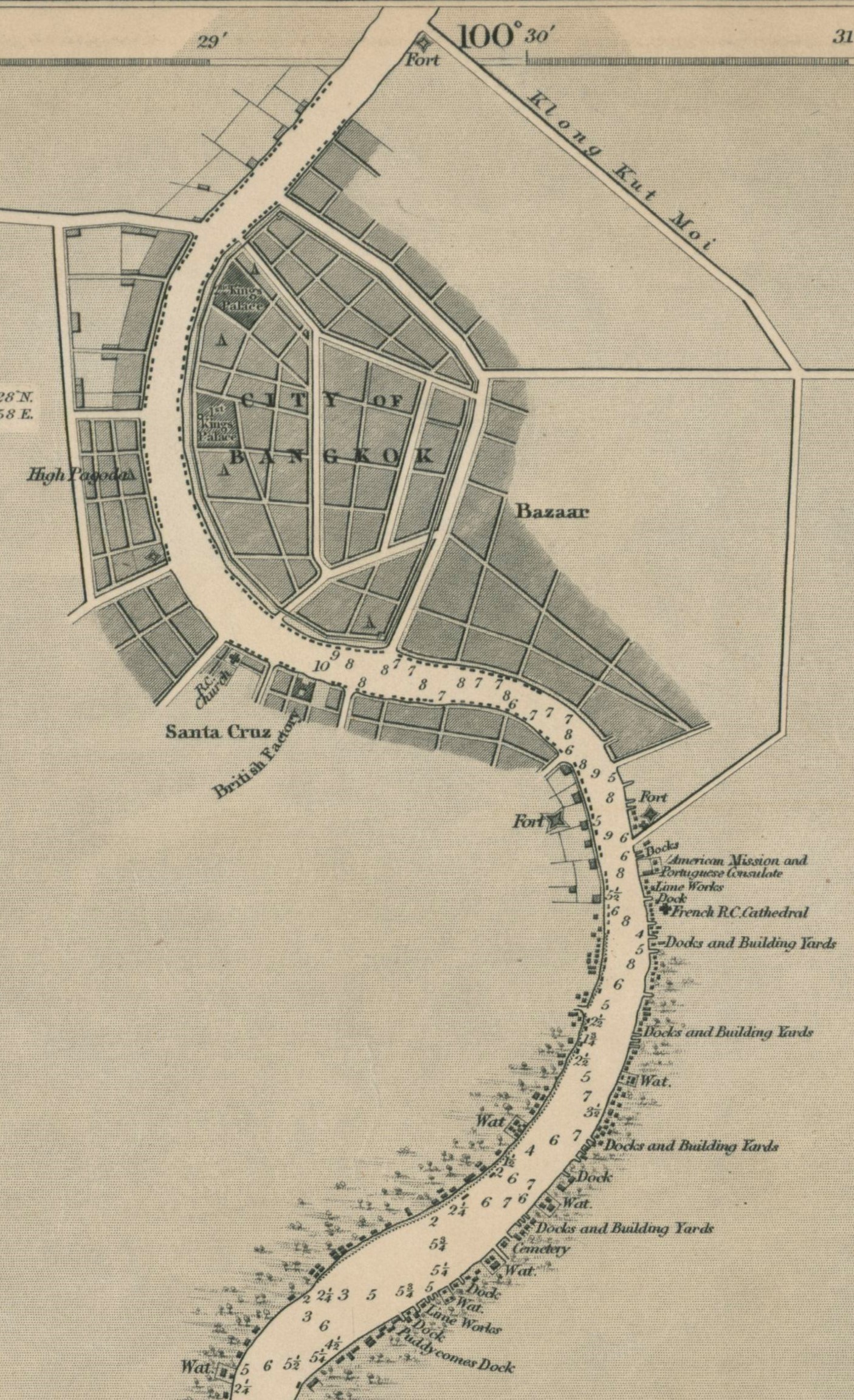
Figure 3 presents a detail of the 1861 map.
Bradley, Bangkok Calendar, 1860, pp. 88-89.
Ibid., pp. 68-71.
For a discussion of Bangkok’s 19th century population, see B.J. Terwiel, Through Travellers’ Eyes: An approach to Early Nineteenth century Thai History (Bangkok: Duang Kamol Books, 1989), pp. 224-233.
These are shown on the first map, ‘Plan of the City of Bangkok’, in Bradley, Bangkok Calendar, 1860.
Bradley’s idiosyncratic transcription system, used in the map legend, was outlined by him in Bangkok Calendar, 1860, p. 51, and repeated and expanded in subsequent editions.
Information on the Chinese merchants has been kindly contributed by Pimpraphai Bisalputra and supplemented by reference to A History of the Thai-Chinese by Jeffery Sng and Pimpraphai Bisalputra (Singapore: Editions Didier Millet, 2015). Information on the Muslim merchants is from Bradley’s Bangkok Calendar, 1860 and Edward Van Roy, Siamese Melting Pot: Ethnic Minorities in the Making of Bangkok (Chiang Mai, Silkworm Books: 2017), pp. 148-149. Van Roy also identifies the locations of the main Chinese speech groups on p. 185.
Bradley, Bangkok Calendar, 1860, pp. 71-72.
Monsignor Jean-Baptiste Pallegoix, Description of the Thai Kingdom or Siam: Thailand under King Mongkut, translated by Walter E. J. Tips (Bangkok: White Lotus, 2000), p. 405.
Bradley’s list of Chinese/Muslim merchants starts on the west bank with the letter references a to x, then switches to the east bank for y, z and a again through to g. The indifferent quality of the map makes some of the referenc
